Menu
Guildford Heritage Forum
  • Home Page
Guildford Heritage Forum

Old Maps

Posted on December 13, 2020February 13, 2021

The National Libraries of Scotland has scanned most of the UK Ordnace Survey Maps from the earliest ones available, Here is a link to the Guildford Maps

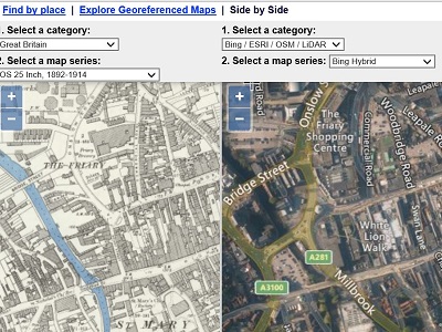
There is also a useful tool that displays a modern satellite view against an old map making it much easier to locate modern streets on old maps from the days when everything was fields. This link takes you to Guildford High Street

Leave a Reply Cancel reply

Your email address will not be published. Required fields are marked *

This site uses Akismet to reduce spam. Learn how your comment data is processed.

Recent Posts

  • Guildford Streets
  • Historic Images
  • History Resources
  • Decolonisation
  • Walks & Talks

Recent Comments

  • Gillian Cameron on Can heritage help post Covid-19 Guildford?

Archives

  • March 2021
  • February 2021
  • January 2021
  • December 2020
  • November 2020
  • October 2020
  • September 2020
  • August 2020
  • July 2020
  • June 2020
  • May 2020
  • March 2020
  • February 2020
  • January 2020
  • November 2019
  • October 2019
  • July 2019
  • June 2019
  • April 2019

Cat

Meta

  • Log in
  • Entries feed
  • Comments feed
  • WordPress.org
©2021 Guildford Heritage Forum | Powered by SuperbThemes & WordPress